Today there is a vast array of weather information tools available online. These resources enable the pilot to have a very good understanding of the weather and tools to make even the most savvy weather briefer envious!
Here are the steps I use to get an idea of the weather:
1) Go to The Weather Channel site and get the "big picture".
2) Go to your local National Weather Service site-Here is the Jackson, MS site.
-On the various NWS sites, one can access a whole host of local weather data.
-The forecast discussion is a good resource to get a feel as what local meterologists think about the upcoming weather.
-Here is the link for the Central MS Forecast Discussion
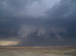
3) Each individual NWS site will have access to their individual radar.
-Here is the link to the current Jackson NWS base radar loop
4) Link for the National radar Loop.
5) Excellent satellite images can be found on this site. Be sure to select animation(the one in red), 100% zoom and click on the map image to get a animated high-res image from the weather satellite.
6) National Aviation Weather site. Here one can access the whole array of info, including Sigmets, PIREPS, and area forecasts.
7) Another interesting source is The Weather Underground. This dubious sounding place has great weather info and outstanding radar images with access to NEXRAD products such as echo tops and radial velocity.
8) Get an online flight planning account. These sites allow access to a full weather brief with aircraft profiles and trip planning.
9) Call your local Flight Service Station, 800-WX-BRIEF, to speak to a real-live human being. If you've followed some of the links above, chances are you may know more about the weather than the briefer. Be aware that the briefer you get may not have a lot of knowledge about your local area. That is the price we will pay for closing local FSS stations. However, the briefer will have been in touch with pilots and can pass along pireps about actual conditions. That can be real handy especially in the winter months with icing forecasts vs. actual conditions. I now use www.fltplan.com to file my flight plans since Lockheed Martin has had so many problems losing plans. At the conclusion of your flight, be sure to close your flight plan and be a responsible pilot and give a PIREP!!
Finally, use common sense. Always check these online products for the correct date and time, they could be very old.
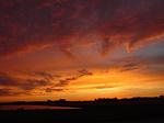
Go outside and look up!! Is there fog forming? Do you see clouds that are building? Do you see any signs of rising air? Dust devils and soaring birds way up, along with a forecast of thunderstorms may make one want to stay on the ground!!
Do the conditions you see with your own eyes agree with the forecast? Remember, forecasts are based on computer models with some human input and can be wrong!!! If you see a few instances where forecasts don't agree with what's really out there, it's probably time to exercise some caution.
Be careful up there and respect that weather!!!!!!!!
|
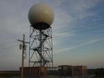 |
| Doppler Weather Radar |
|
|